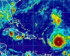
Hurricane Irma, a dangerous Category 4 storm, still has Florida firmly in its sights as it continues its westerly trek approaching the Caribbean islands with an inevitable turn to the north upcoming.
A hurricane warning remains in effect for Puerto Rico, the U.S. Virgin Islands and other Caribbean locations, and Florida Gov. Rick Scott declared a preemptive state of emergency during Monday’s Labor Day holiday, allowing emergency management officials to start preparations.
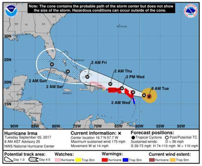
As of Tuesday at 8:28 a.m., Irma is packing 175 mph winds as it heads west for the Leeward Islands at 14 mph. At that slow speed, with that level of destructive power, this storm could do major damage as it crosses over Florida.
HURRICANE GUIDE: Emergency information, tracking map and storm resources
It is located about 320 miles east of the islands, with a path toward Puerto Rico, Cuba, and possibly, eventually Florida.
“Hurricane Irma is a major and life-threatening storm and Florida must be prepared,” Scott said in a statement on Monday. “In Florida, we always prepare for the worst and hope for the best and while the exact path of Irma is not absolutely known at this time, we cannot afford to not be prepared.”
In our featured image (courtesy of the National Hurricane Center in Miami), the location of the storm can be seen, but not its size. In this following image, you can compare the size Irma with the size of the state of Florida to fully appreciate the magnitude of this storm.

On its current track, Irma will move over the northern Leeward Islands Tuesday night or early Wednesday. Irma will likely maintain Category 5 strength, and the center will pass to the north of the Dominican Republic and Cuba — and could be near the southern tip of Florida by Sunday morning beginning its expected northerly turn, 10Weather WTSP meteorologist Grant Gilmore said.
DOWNLOAD: Get the tbo Weather App and see where storms are headed
“There is some uncertainty as to when and where that turn to the north will occur,” Gilmore said.
On its current track, the Tampa Bay area has a 21 percent chance of experiencing tropical storm force winds by Sunday morning.
LIVE RADAR: Interactive storm track, hourly outlooks, 10-day forecasts and weather alerts
Forecasters say hurricane conditions will arrive in the warning areas by tonight, and Irma could produce up to 12 inches of rain across Puerto Rico and the U.S. Virgin Islands and the northern Leeward Islands.
The Leeward Island could experience tides between 6 and 9 feet above normal, as well as life-threatening flash floods and mudslides.
This is a developing story. Stay with OrlandoAdvocate.com for updates


