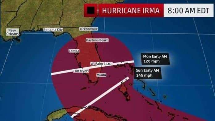
Hurricane Irma is coming. The storm is so big that just the residual impacts of the outer winds could be catastrophic. Remember, Hurricane Harvey did its worst damage after it was downgraded to a Tropical Storm.
Irma is still increasing in speed. Wind velocity has actually increased to 185 mph. GET READY for this storm now, and don’t wait until the last minute. Foodstuffs are flying off the shelves. Gas is disappearing as vehicle owners fuel up in preparation for what’s coming. Gov. Scott has suspended tolls throughout the state to make it easier for Floridians to evacuate. Yes, evacuate. This storm is a BEAST. It is already the most intense Atlantic hurricane in 12 years.
South Florida Threat
It is impossible to pinpoint at this time where Irma is going to hit Florida, but as we stated up above, this storm is huge. If Irma’s center stays to the southern edge of the cone, the damage to South Florida won’t be as severe. But it the hurrricane stays in the middle of the cone or tracks toward the north, The Weather Channel says “an intense eyewall strike on South Florida would occur, with potentially devastating, destructive winds, in addition to life-threatening storm surge flooding and torrential rainfall.”
Conditions in South Florida could go bad very quickly as soon as midday Saturday, so again, don’t put off preparations until the last minute.
(MORE: Are You in an Evacuation Zone?)
If you are in an evacuation zone, gas up and get out. Now, if you can. Or you might find yourself stuck on a highway that has turned into a parking lot because everyone else like you decided to wait until the last minute to leave. As the Weather Channel strongly states: “This is not a hurricane you want to risk riding out.”
The 64 dollar question is this: When and where will Irma make its northward turn? Because it will turn north sooner or later.
There appear to be three general scenarios.
Scenario A: A Turn up the Atlantic Ocean
- This is what Hurricane Matthew did in October 2016.. It ran up along Florida’s eastern coast battering parts of the state and then ravaged the Carolinas.
- WESH 2 News has a up-to-date listing of distribution centers throughout Central Florida.
Scenario B: A Run Up the Middle of the State
This would take Irma’s center over much of the Florida Peninsula. Traveling over land would weaken the storm, but not enough to avoid the devastation it would cause by knocking down trees and powerlines and destroying homes. The winds would cause significant storm surge flooding at the coast, and possibly on both sides of the state.(MORE: Beware of ‘I’ Hurricanes)
Scenario C: A Late Turn After Passing Florida
- This track would spare most of Florida and see Irma pass over the eastern Gulf of Mexico. Landfall would then take place somewhere along the north-central or northeast Gulf coast early next week. Under this scenario, Irma would probably get even stronger, with a devastating strike on the northern Gulf Coast.
Right now any of these scenarios is possible.
The Size of the Beast
Even without knowing which scenario we will face, what is probably a foregone conclusion is that the Southeast and at least eastern Gulf Coasts will sustain major damage as a result of this storm. Blame the coastal flooding expected to happen as soon as Friday and the life-threatening storm surge flooding that will occur both to the north and east of Irma’s path.
The ‘Don’t Make No Sense’ Of It All
As if Irma, following Harvey, wasn’t enough, Storm Jose just turned into a hurricane. And it’s following Irma.
WESH 2 News has a up-to-date listing of distribution centers throughout Central Florida.


